

Search

Hongke's latest articles

HongKe

Lorem ipsum dolor sit amet, consectetur adipiscing elit. Ut elit tellus, luctus nec ullamcorper mattis, pulvinar dapibus leo.

Lorem ipsum dolor sit amet, consectetur adipiscing elit. Ut elit tellus, luctus nec ullamcorper mattis, pulvinar dapibus leo.

How can GNSS simulators enable drone testing? The Key Technology Behind Efficient Testing

Background

A drone research and development company needs to complete a new generation of inspection drones.Machine TestingThe first step is to validate its performance in complex environments:

  • Navigation Positioning Accuracy
  • Multi-GNSS constellation compatibility
  • immunity to interference
  • Multi-sensor fusion performance

The test scene needs to be covered:

  • City Canyon(Multipath effect is severe)
  • Mountainous terrain(Signal blocking is frequent)


Limitations of the Traditional Test Program

Conventional field flight testing is limited byWeather conditions, airspace approvals, safety risks, and non-reproducible test scenariosThe R&D program has not been able to satisfy the needs of modern R&D.High efficiency and controllabilityThe needs of the

To solve these problems, companies are turning toLaboratory Simulation Test ProgrambyHONGKE Simulation and Automation Test PlatformIt is the first time in the world that we have realized full-scene coverage and accurate verification.

Hi-Tech Solutions

HONGKE Simulation and Automation Test Platform

1. Hardware Configuration

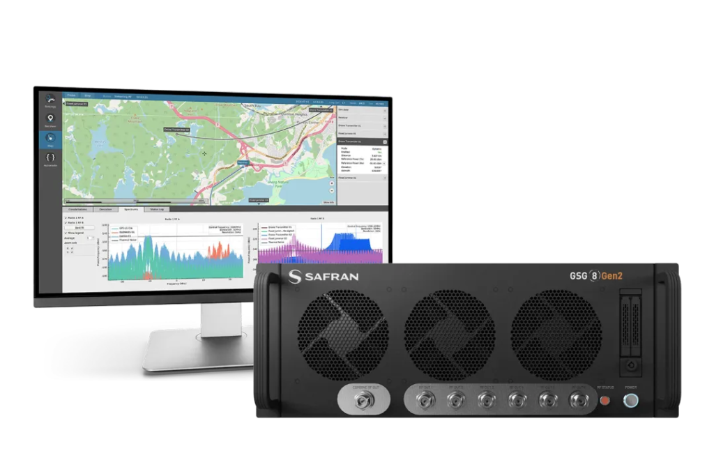
Hongke GNSS Simulator GTS-P7

✓ Optimized multi-instance hardware architecture
✓ Support for simulation 6 independent GNSS test sites

GTS-P7 It is a set based on Skydel s** Positioning, Navigation and Timing (PNT)** test solution provides high specification GNSS signal simulation capabilities in an easy-to-use, one-stop, small footprint format.

The system has 1000 Hz analog iteration rateSupport for Kodak 700 satellite channelsThe following is a list of the most common features that can be realizedHighly dynamic, real-time synchronized signal simulationandFull Field of View Satellite Signal CoverageThe Simultaneous SupportMulti-constellation, multi-band GNSS simulationIt can also be programmed to simulateAll existing and future GNSS signalsThe

2. Software Tool Chain

GNSS Simulation Software

✓ Support for major GNSS constellations and frequency bands worldwide
✓ Support multi-vehicle and multi-antenna simulation testing

Skydel simulation engineCombines the performance of a high-end GNSS simulator with the flexibility and cost-effectiveness of the **Software Definition Architecture (SDA)** for a complete and rich feature set, including:

  • Support Gundam 1000 satellite channels
  • 1000 Hz Simulation Iteration Rate
  • Remote control via user-defined scripts
  • Software-defined architecture for superior flexibility and scalability

The platform supportsMultiple RF output channelsandThousands of simulated satellite channelsHe is also capable of high level system integration and software development.

HONGKE GNSS simulation automation test platform

✓ Provides automated testing capabilities that meet industry standards

The HONGKE GNSS simulator can be used as a stand-alone system or combined with the HONGKE GNSS simulator.Automated Standard Validation ToolsEmbedded deployment for standards implementationOne-Click Scene Configuration and Global ControlThe company is responsible for completing testing and validation to meet standard requirements and supportingAutomatic test report generation and exportIt is easy to retain and trace.

Test Scene Design

All tests are conducted inLaboratory EnvironmentThis is accomplished without the need for actual flight operations, ensuring that theTest safety and high reproducibilityThe

Test Item Description

1. Static calibration

  • Simulated Satellite Elevation Angle 0°-90° Full coverage

  • Dynamically adjusts multi-constellation signal strength (-130 dBm to +20 dBm)

  • Verify drone cold-start positioning accuracy (target.):< 1 m RMS)

2. Dynamic flight simulation

  • Generation of specific trajectories: S-courses, sharp turns (radius < 10 m), climbs/dives (acceleration ±5 g)

  • Testing in high dynamic environments DOP value stabilizationTrouble with heading control

3. anti-interference test

  • GNSS Simulator Synchronized OutputIn-band/out-of-band interference signals

  • Includes narrowband, broadband and pulsed interference.

  • Verification of receiver positioning availability and resilience in interference environments

4. RTK positioning accuracy test

  • Analog base station and mobile station differential signaling

  • Introducing Dynamic Baseline Changes and Network Latency

  • Verification RTK centimeter positioningReliability in high-precision operations

Program Value

Test Solution Core Benefits

★ Excellent performance indicators

✓ Seamless switching and combining of multiple constellations, supporting the free matching of the four global systems.
✓ High-precision performance.Artificial distance accuracy ≤ 1 mm
✓ Complete anti-interference testing capability, supporting multiple interference signal combinations, superposition and false-coordinate simulation

★ Significant efficiency gains

✓ Covered in a single test 10 Typical Scenes
✓ Traditional field test takes about 10 days → Laboratory test only 8 hours
✓ Failure Recovery Rate Increased to 100%The system can accurately play back anomaly traces and quickly locate the problem.

★ Significant cost optimization

Lower cost of airspace applications 90%
✓ Lower depreciation costs for field labor and equipment 40%
✓ Shorter test cycles 70% Above

Industry Application Extension

The test solution has been successfully applied to a number of drone sub-areas:

★ Logistics Drones

✓ Power Line Obstacle Avoidance and Autonomous Return Test in Simulated Mountainous Complex Terrain
✓ Validate inertial navigation relay capability after loss of GNSS signals during long distance flights

★ Inspection Drones

✓ Bonding 5G Return LinkVerify low latency (< 50 ms) path planning and obstacle avoidance responses.
✓ Multi-sensor fusion testing (GNSS + IMU + Visual SLAM) Consistency Assessment

Conclusion

based onSoftware Definition Architecture (SDA)(math.) genusHONGKE GNSS SimulatorEffectively solves the problem of drone testingUncontrollable environment, high cost, long cycle timeand other core pain points. ItsMulti-constellation co-simulation, RTK high-precision positioning test and multi-sensor fusion verification capabilitiesIt has become an important industry tool in the development of smart aircraft.

Looking ahead, the combination of AI-Driven Adaptive Scene Generation(e.g., deep learning-based interference pattern prediction) will further drive drone testing towardIntelligence and AutomationDevelopment.

Other Articles

Hongke Case

AI Recognition and AR Workflow: Reinventing PCB Quality Assurance and Digital Factory

Facing PCB Quality Inspection Yield Bottleneck? HongKe HongKe provides AR standardized workflow + AI recognition solution to reduce visual inspection rate by 50% and shorten new employee training to 1 day. Applicable to Hong Kong and Southeast Asia electronics manufacturing transformation, helping you realize efficient quality control and quality traceability.

Read more

Contact Hongke to help you solve your problems.

Let's have a chat