


Search

Hongke's latest articles

HongKe

I. Introduction: Strategic Changes at the Data Layer under the Critical Infrastructure Legislation

Add your title text here

[Hongke Solutions] GNSS Simulators Respond to the Strait of Hormuz Incident

In February 2026, widespread GNSS signal anomalies were observed in the Strait of Hormuz and surrounding waters.. Sudden jumps in vessel positions; AIS tracks abnormally appearing at airports, nuclear power plants, or even inland areas; and vessel group trajectories forming “circles” or “zigzags.”. A large number of vessels were forced to slow down, drop anchor, change course, or even shut down their AIS systemsThe

Daily oil shipments through the Strait of Hormuz account for approximately 20 percent of the global total; oil tankers loaded with hundreds of thousands of metric tons of crude oil and measuring up to 300 meters in length require a considerable distance to turn or come to a stop.. When the exact positions of nearby vessels cannot be determined, the risk of collision increases significantly. This incident demonstrates that GNSS signal interference and spoofing are sufficient to make it difficult for commercial vessels to navigate through high-traffic watersThe

In the face of increasingly severe electromagnetic threats, how can manufacturers of positioning devices ensure that their devices maintain a minimum level of security even when signals are interfered with or spoofed?? This article will provide an in-depth analysis of the mechanisms underlying GNSS signal vulnerabilities and presentHongke GNSS Simulator SolutionHow to Help Multiple Industries Overcome Complex Location Verification ChallengesThe

顯示霍爾木茲海峽 GNSS 干擾事件中,船舶位置跳變與圓圈異常航跡的衛星地圖

I. The Intrinsic Vulnerability of GNSS Signals

The fundamental reason GNSS is susceptible to interference is that the satellite signal power reaching the receiver antenna is extremely low.. For example, among the minimum receive power levels specified in the GPS SPS standard, L1 C/A is approximately -158.5 dBW, L2C is approximately -160.0 dBW, and L5 is approximately -157.9 dBW (the L1 carrier frequency is 1575.42 MHz, and the C/A code rate is 1.023 Mcps).The

Real GNSS signals are inherently buried more than ten dB below the noise floor; receivers operate based on pseudocode correlation, long-term accumulation, and tracking loop gain, rather than by “directly seeing” the satellite signals.The

From the perspective of signal mathematical models, the receiver input can be expressed as:

 
其中 s(t) 是真實衛星擴頻訊號,j(t) 是人為干擾或偽造訊號,n(t) 是熱噪聲。

included among these s(t) It is a real satellite spread-spectrum signal,j(t) It is human-induced interference or a falsified signal,n(t) It is thermal noise.The

II. The Impact of Spoofing on Location Determination

The essence of the deception lies in constructing an interference signal with “correct correlation structure but false geometric relationships,” causing the receiver to continue outputting a position solution that is, however, entirely controlled by the attacker.. GNSS spoofing is more dangerous than jamming; its goal is not to prevent the receiver from “determining its position,” but rather to cause it toConsistently locating the wrong spotThe

1. Relay-based spoofing (Beaconing / Replay)

After receiving the actual satellite signal, it is relayed and an additional delay is introduced, causing the pseudorange to increase overall and shifting the position solution toward an offset point.. Since the signal originates from a real satellite, it is extremely difficult for the targeted device to detect it.The

2. Generative Spoofing

The attacker synthesizes PRN codes, carrier frequencies, and navigation messages on the ground that match those of a real satellite. First, the attacker “captures” the receiver using slightly higher power, then slowly shifts the code phase, carrier phase, and Doppler frequency, causing the position solution to continuously drift toward a target false position.The

III. Hongke GNSS Simulator: Reproducing Extreme Threat Environments in the Laboratory

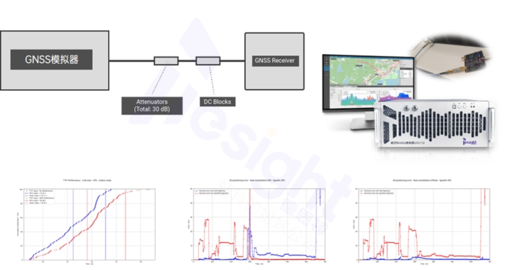
Regarding Position Jumps, Deviations from the Course, and Circular/Zigzag Trajectories in the Strait of Hormuz Incident, or extreme situations such as temporary interference with civilian frequency bands that prevents devices from determining their location(math.) genusHONGKE GNSS SimulatorAllows for the precise replication of corresponding jamming and spoofing environments in a laboratory settingThe
顯示 GNSS 衰減與模擬測試下的 TTFF 分佈與 2D 定位誤差分析性能曲線圖。

Core Advantages of the Hongke Solution:

1. Full-Scene Signal Generation

Can generate a wide range of GNSS signal conditions, from ideal electromagnetic environments to extreme composite interference (suppressive interference, relay spoofing, and generative spoofing)The

2. Early Evaluation and Algorithm Optimization

Help device manufacturers comprehensively evaluate navigation performance across various potential scenarios early in the product development process and optimize anti-interference and Kalman filter algorithms.The

3. Highly Reproducible Validation

Overcoming the drawbacks of field testing—such as unpredictability and high costs—by conducting standardized, automated, and consistent testing in the laboratoryThe

IV. Applications of Hongke GNSS Simulators Across Multiple Industries

Conducting systematic anti-interference and anti-spoofing tests on positioning devices using the Hongke GNSS simulator allows for thorough verification of their accuracy and robustness in complex electromagnetic environments prior to deployment.The

1. Cars and Autonomous Driving

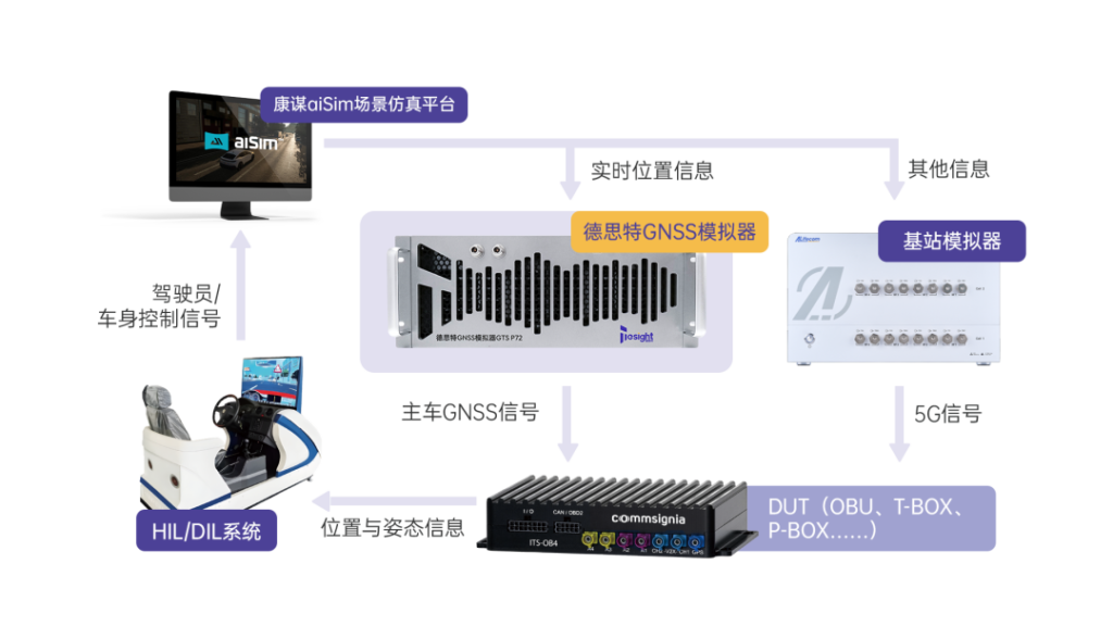
整合虹科 GNSS 模擬器與基站模擬器的自動駕駛 HiL / DIL 系統測試架構圖。
Supports HiL (Hardware-in-the-Loop) high-real-time simulation testing to address navigation latency challenges and verify the safety of high-precision positioning for autonomous vehicles in tunnels, on urban elevated roads, and in the presence of electromagnetic interference.The

2. Low-Altitude Economy (Drones)

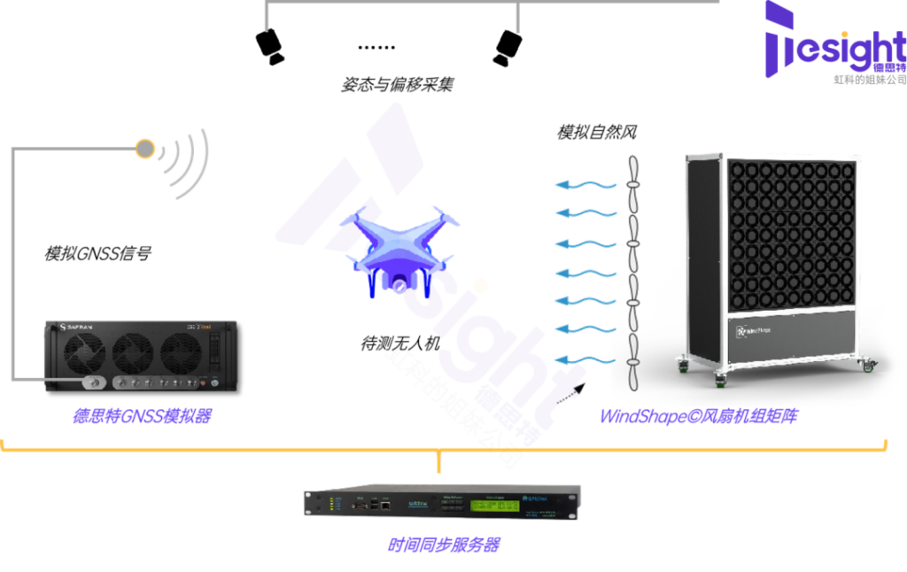
用於無人機定位驗證的虹科 GNSS 模擬器與 WindShape 風扇風洞矩陣測試架構圖
Enables comprehensive drone testing and wind tunnel testing to simulate hovering, route flight, and autonomous landing capabilities under complex airflow conditions and signal obstructionThe

3. Consumer Electronics and Embodied Intelligence

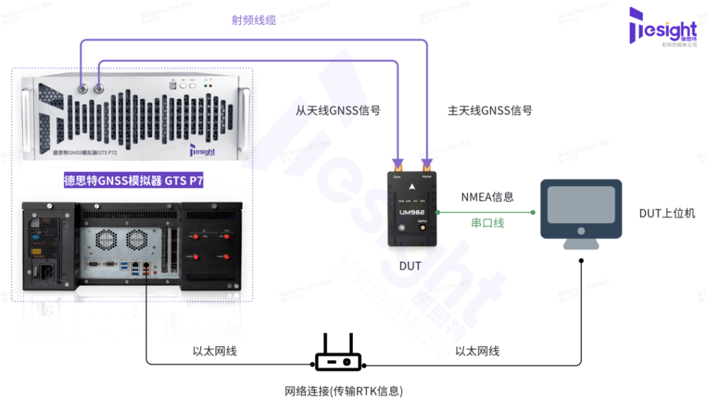
虹科 GNSS 模擬器 GTS P7 與 RTK 接收機用於精準定位驗證的硬體連接拓撲圖。
Overcoming the Limitations of Outdoor Testing to Enable High-Precision Localization Validation for Robots and Wearable Devices in Complex Indoor-Outdoor Boundary ScenariosThe

Conclusion

From shipping to automobiles, from drones to consumer electronics, only positioning devices that have undergone thorough simulation and validation can maintain the minimum standards for accuracy and safety in complex electromagnetic environments.TheHongke GNSS Simulator SolutionBy recreating real-world threat environments in the lab, devices are put through rigorous testing before they are deployed.The

Please contact the Hong Technology team to schedule a personalized consultation. GNSS Simulation Test Architecture Design and 1-on-1 Technical Consulting.

Other Articles

Hongke Dry Goods

[Hongke Solutions] Human-Factors Risk Management in Cybersecurity: Case Studies and KnowBe4 Best Practices

Faced with human-related cybersecurity risks, how can enterprises effectively prevent data breaches? This article provides an in-depth analysis of the latest enforcement cases, covering vulnerabilities in public code repositories, data APIs, and malicious activities by former employees. By combining Hongke’s KnowBe4 phishing simulations, AIDA real-time coaching, and compliance requirements, we help Hong Kong enterprises build a robust defense system that integrates technology, policies, and personnel.


Read more
虹科 aiSim 智駕仿真平台軟體介面:支援 OpenDRIVE 與 Atlas 地圖格式轉換及非結構化道路場景編輯
Hongke Case

[Hongke Solutions] aiSim Intelligent Driving Simulation: A Comprehensive Guide to Unstructured Road Testing

An In-Depth Analysis of How Autonomous Driving Simulation Solves the Challenges of Unstructured Road Testing! Hongke’s aiSim solution integrates OpenDRIVE-to-Atlas map conversion and utilizes Unreal Editor and Blender to create high-fidelity terrain and road surface models, providing vehicle dynamics feedback and closed-loop testing of physical sensors to comprehensively accelerate the validation of Level 3 and Level 4 autonomous driving algorithms. Learn more about efficient scene construction now!

Read more
Hongke Dry Goods

[Hongke Solutions] Does AI Struggle to Understand Business Needs? Overcoming AI Context Disconnects and Real-Time Data Bottlenecks in Enterprises

Failed Enterprise AI Implementation? The Problem Isn’t the LLM Model! Hongke analyzes the devastating impact of the “Enterprise AI Context Gap” on Copilot and Agentic workflows and introduces the Redis Iris real-time context layer architecture to help B2B enterprises in Hong Kong and Southeast Asia build high-return AI systems.

Read more

Contact Hongke to help you solve your problems.

Let's have a chat