
Search

Hongke's latest articles

HongKe

[Hongke Solutions] aiSim Intelligent Driving Simulation: A Comprehensive Guide to Unstructured Road Testing

With the rapid advancement of intelligent and autonomous driving technologies today, the industry’s evaluation framework has shifted from a sole focus on “test mileage” to a more comprehensive assessment of “scenario coverage” and “edge cases.”. Statistics show that the validation of a mature autonomous driving algorithm typically follows "99.91 TP3T simulation testing + 0.091 TP3T closed-course testing + 0.011 TP3T public road testing" The Golden RatioThe

However, as autonomous driving systems advance to Levels 3 and 4, or when operating in special areas such as mining sites, rural areas, and mountainous regions, the lack of clear lane markings and uneven road surfacesUnstructured Roads, becoming a key bottleneck that hinders the system's actual implementation and reliable operationThe

虹科 aiSim 智駕仿真平台軟體介面:支援 OpenDRIVE 與 Atlas 地圖格式轉換及非結構化道路場景編輯

1. Why is the unstructured road test essential?

In the traditional definition of the Operational Design Domain (ODD), unstructured roads are often classified as specific scenarios; however, in real-world traffic environments, rural roads, mountain roads, temporary construction zones, and industrial park roads account for a significant proportion.The

Structured roads provide prior information from high-definition maps (HD Maps) and defined lane markings, whereas unstructured roads lack such information, requiring the system to rely entirely on its own perception and decision-making capabilities.::

  • Missing or Faded Lane Markings: Vehicles rely on multiple sensors, such as cameras and LiDAR, to determine in real time which areas are safe to drive in.The

  • The road has a complex geometric configuration: Featuring sharp turns, a series of curves, and steep slopes, this course places higher demands on vehicle dynamics control and trajectory planning.The

  • There is a significant coupling between topography and environmental factors: Undulations, potholes, and mixed materials create a three-dimensional structure that directly affects a vehicle's maneuverability and handling stability.The

2. Two Major Challenges in Traditional Unstructured Road Simulation

Currently, mainstream simulation map generation relies heavily on standard formats such as OpenDRIVE. These formats are primarily designed for structured road networks and are particularly effective at describing lane topology and intersection connections.. When encountering dirt roads built along mountainsides or with damaged surfaces, the following challenges arise::

Limited terrain modeling capabilities

When traditional maps are imported into simulations, they are typically flat projections that lack elevation and road surface details; the dynamic feedback is still based on the assumption of a flat road surface.The

Lack of flexibility in scene editing

If you build a scene from scratch using professional 3D modeling tools, it often lacks pathfinding information, making it difficult to test scene interactions.The

This creates a dilemma:Either use "ideal roads" that lack realistic terrain, or use "purely visual scenes" that are difficult to integrate with test logic.The

3. aiSim: A High-Performance Solution for Unstructured Road Simulation

To overcome the aforementioned bottleneck,aiSim Intelligent Driving Simulation Platform By integrating external 3D editing tools, we have established an efficient workflow that seamlessly combines logical road networks with highly realistic terrain.The

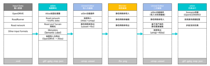
Basic Data Conversion: From OpenDRIVE to Atlas

aiSim supports direct import of industry-standard OpenDRIVE Format the map and convert it to the built-in Atlas Map Format. The Atlas format preserves road networks, semantic labels, traffic information, and topographic data, enabling maps to be expanded and edited further.The

Flexible Terrain Editing: Integration Between the Unreal Editor and Blender

With the aiSim plugin, users can Unreal Editor Directly access map resources within the application, and with the help of Blender Perform grid editing::

  • Large-Scale Terrain Reshaping: Redistribute the terrain grid to generate varied terrain undulations and mountain slopesThe

  • Detailed Rendering of the Road Surface: Simulates road surface features such as cracks, bumps, and ruts, and assigns them realistic physical collision properties and material characteristicsThe

Closed-Loop Test Validation: High-Fidelity Sensors and Physical Simulation

Edited unstructured maps can be imported directly into aiSim for physical closed-loop testing.::

  • Vehicle Dynamics Feedback: Road surface irregularities and changes in gradient will directly affect the vehicle model's attitude and wheel responseThe

  • Sensor Simulation: To reproduce the point cloud patterns captured by radar on gravel roads and the rolling shutter effect observed by cameras under bumpy conditions, thereby providing accurate ground truth for the validation of perception algorithms.The

4. Conclusion

aiSim Intelligent Driving Simulation Solution It provides an efficient approach to testing autonomous driving in complex road environments. Through the logical conversion from OpenDRIVE to Atlas, combined with the terrain editing capabilities of the Unreal Editor and Blender, the testing team can easily replicate various edge-case scenarios in a virtual environment without incurring the high costs of on-site data collection and high-risk real-world vehicle testing, thereby accelerating the iteration and safety validation of autonomous driving algorithms.The

Go NowaiSim PageLearn more.

Other Articles

Hongke Dry Goods

[Hongke Solutions] Beyond Signals: Decoding Desite’s “Full-Stack” Technical Depth in the GNSS Field

In the GNSS field, many companies remain stuck at the “application-layer implementer” stage and struggle to meet challenges such as drone swarm coordination, high-precision positioning in extreme environments, and anti-jamming encrypted communications. Deste (a Hongke partner) has broken through the limitations of superficial integration to build end-to-end technical depth spanning “underlying technology—testing and validation—complex scenario applications.” This article provides an in-depth analysis of how Destar, through its strategic portfolio of patents and software copyrights, has built a GNSS technology moat from the “ground up.”


Read more
Hongke Dry Goods

[Hongke Insights] Behind the $135.6 Billion Overseas Expansion Bonanza, a Single Data Breach Could Undo All Efforts

The global cross-border e-commerce market is valued at a staggering $135.6 billion! However, when it comes to exporting fresh produce, pharmaceuticals, and sensitive, high-value products, gaps in environmental monitoring and data compliance are becoming a critical vulnerability for businesses. A single data interruption or temperature deviation could result in the destruction of an entire shipment and exorbitant fines. This article provides an in-depth analysis of the three major data risks in the cross-border supply chain and introduces Hongke ELPRO’s enterprise-grade data logging and cold chain monitoring solutions.

Read more
以DoIP網關為核心,虹科CANnector系列設備透過延遲最小化的協定轉換、獨立運行的硬體架構、以及一體化的測試平台能力,幫助客戶在電池 ECU 快閃記憶體環節實現了20%的效率躍升。
Hongke Dry Goods

[Hongke Solutions] Tight production line cycle times? Hongke CANnector enables efficient battery system testing with its DoIP gateway capabilities.

Production line cycle times for new energy vehicles are extremely tight, and traditional CAN buses face transmission bandwidth bottlenecks during Battery Management System (BMS) and battery pack testing. Leveraging its powerful DoIP (Diagnostics over IP) gateway capabilities, Hongke CANnector enables high-bandwidth, low-latency diagnostics and programming, significantly reducing production line test cycle times. This article provides an in-depth analysis of how CANnector overcomes transmission bottlenecks and enables efficient testing of battery systems.

Read more

Contact Hongke to help you solve your problems.

Let's have a chat