

Search

Hongke's latest articles

HongKe

[Hongke Solutions] aiSim Intelligent Driving Simulation: A Comprehensive Guide to Unstructured Road Testing

With the rapid advancement of intelligent and autonomous driving technologies today, the industry’s evaluation framework has shifted from a sole focus on “test mileage” to a more comprehensive assessment of “scenario coverage” and “edge cases.”. Statistics show that the validation of a mature autonomous driving algorithm typically follows "99.91 TP3T simulation testing + 0.091 TP3T closed-course testing + 0.011 TP3T public road testing" The Golden RatioThe

However, as autonomous driving systems advance to Levels 3 and 4, or when operating in special areas such as mining sites, rural areas, and mountainous regions, the lack of clear lane markings and uneven road surfacesUnstructured Roads, becoming a key bottleneck that hinders the system's actual implementation and reliable operationThe

虹科 aiSim 智駕仿真平台軟體介面:支援 OpenDRIVE 與 Atlas 地圖格式轉換及非結構化道路場景編輯

1. Why is the unstructured road test essential?

In the traditional definition of the Operational Design Domain (ODD), unstructured roads are often classified as specific scenarios; however, in real-world traffic environments, rural roads, mountain roads, temporary construction zones, and industrial park roads account for a significant proportion.The

Structured roads provide prior information from high-definition maps (HD Maps) and defined lane markings, whereas unstructured roads lack such information, requiring the system to rely entirely on its own perception and decision-making capabilities.::

  • Missing or Faded Lane Markings: Vehicles rely on multiple sensors, such as cameras and LiDAR, to determine in real time which areas are safe to drive in.The

  • The road has a complex geometric configuration: Featuring sharp turns, a series of curves, and steep slopes, this course places higher demands on vehicle dynamics control and trajectory planning.The

  • There is a significant coupling between topography and environmental factors: Undulations, potholes, and mixed materials create a three-dimensional structure that directly affects a vehicle's maneuverability and handling stability.The

2. Two Major Challenges in Traditional Unstructured Road Simulation

Currently, mainstream simulation map generation relies heavily on standard formats such as OpenDRIVE. These formats are primarily designed for structured road networks and are particularly effective at describing lane topology and intersection connections.. When encountering dirt roads built along mountainsides or with damaged surfaces, the following challenges arise::

Limited terrain modeling capabilities

When traditional maps are imported into simulations, they are typically flat projections that lack elevation and road surface details; the dynamic feedback is still based on the assumption of a flat road surface.The

Lack of flexibility in scene editing

If you build a scene from scratch using professional 3D modeling tools, it often lacks pathfinding information, making it difficult to test scene interactions.The

This creates a dilemma:Either use "ideal roads" that lack realistic terrain, or use "purely visual scenes" that are difficult to integrate with test logic.The

3. aiSim: A High-Performance Solution for Unstructured Road Simulation

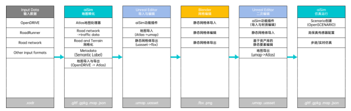
To overcome the aforementioned bottleneck,aiSim Intelligent Driving Simulation Platform By integrating external 3D editing tools, we have established an efficient workflow that seamlessly combines logical road networks with highly realistic terrain.The

Basic Data Conversion: From OpenDRIVE to Atlas

aiSim supports direct import of industry-standard OpenDRIVE Format the map and convert it to the built-in Atlas Map Format. The Atlas format preserves road networks, semantic labels, traffic information, and topographic data, enabling maps to be expanded and edited further.The

Flexible Terrain Editing: Integration Between the Unreal Editor and Blender

With the aiSim plugin, users can Unreal Editor Directly access map resources within the application, and with the help of Blender Perform grid editing::

  • Large-Scale Terrain Reshaping: Redistribute the terrain grid to generate varied terrain undulations and mountain slopesThe

  • Detailed Rendering of the Road Surface: Simulates road surface features such as cracks, bumps, and ruts, and assigns them realistic physical collision properties and material characteristicsThe

Closed-Loop Test Validation: High-Fidelity Sensors and Physical Simulation

Edited unstructured maps can be imported directly into aiSim for physical closed-loop testing.::

  • Vehicle Dynamics Feedback: Road surface irregularities and changes in gradient will directly affect the vehicle model's attitude and wheel responseThe

  • Sensor Simulation: To reproduce the point cloud patterns captured by radar on gravel roads and the rolling shutter effect observed by cameras under bumpy conditions, thereby providing accurate ground truth for the validation of perception algorithms.The

4. Conclusion

aiSim Intelligent Driving Simulation Solution It provides an efficient approach to testing autonomous driving in complex road environments. Through the logical conversion from OpenDRIVE to Atlas, combined with the terrain editing capabilities of the Unreal Editor and Blender, the testing team can easily replicate various edge-case scenarios in a virtual environment without incurring the high costs of on-site data collection and high-risk real-world vehicle testing, thereby accelerating the iteration and safety validation of autonomous driving algorithms.The

Go NowaiSim PageLearn more.

Other Articles

Hongke Dry Goods

HONGKE SOLUTIONS] The Effect of Gaussian Noise on Positioning Effect in GNSS Simulation

In Global Navigation Satellite System (GNSS) radio frequency simulation testing, Gaussian white noise (AWGN) is typically regarded as the baseline configuration for replicating real-world electromagnetic environments. However, engineering practice has shown that the impact of noise on a receiver’s positioning performance does not follow a linear, monotonic relationship. Based on actual measurement data from the DST GNSS simulator, this paper analyzes the physical mechanisms of Gaussian noise in Kalman filters, correlator jitter, and phase-locked loops, and provides a scientific testing guide for configuring simulation noise.


Read more
虹科 ELPRO 醫藥冷鏈實驗室技術人員操作 LIBERO 系列溫濕度記錄儀與監測設備。
Hongke Case

[Hongke Case Study] ELPRO LIBERO Series Temperature Loggers—Ensuring the Safety of High-Value Biopharmaceuticals

High-value novel biopharmaceuticals have extremely stringent cold chain temperature control requirements; even the slightest temperature deviation can result in losses of tens of millions of yuan and pose compliance risks. Using the example of a major domestic pharmaceutical group’s implementation of Hongke’s ELPRO LIBERO series temperature loggers, this article provides an in-depth analysis of how the system achieves zero-incident temperature control throughout the entire process (2°C to 8°C) and dual compliance with GSP and international standards through the automatic generation of tamper-proof PDF reports, SmartStart batch configuration, and standardized SOP services.

Read more
Hongke Dry Goods

[Hongke Solutions] Say Goodbye to Expensive Manual Annotation! aiData 4D Automatic Annotation Technology Enables a Closed-Loop ADAS Data System

In the development of ADAS and autonomous driving, the high cost and lengthy cycle of manual annotation severely hinder algorithm iteration. Hongke’s aiData Auto Annotator solution (developed by aiMotive) utilizes 4D environmental models and neural computing technology to achieve fully automated, high-precision annotation of dynamic 3D bounding boxes and static lane markings. Its annotation accuracy exceeds the human benchmark and can reduce annotation costs by more than 90%, providing an efficient and scalable closed-loop data system for autonomous driving R&D.

Read more

Contact Hongke to help you solve your problems.

Let's have a chat